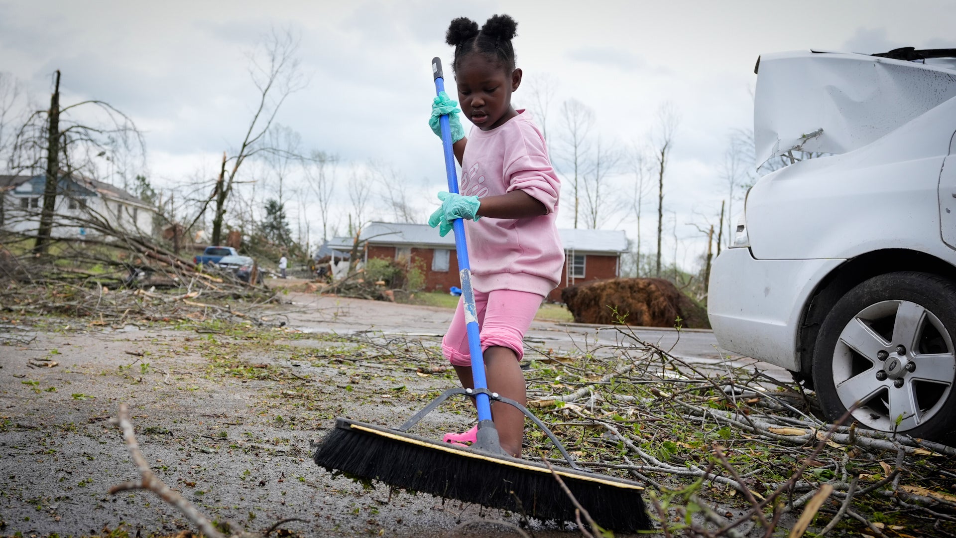
Syracuse, NY

01:06 PM EDT am 21. Mai 2012 (GMT -0400)
Höhe: 404 ft
Län: 76.2° W
Bre: 43.0° N
Datenquelle
Echtzeit-Updates™
Aktualisiert 13:05 EDT Kostenlose Wetter Banner® Share:
Your Custom Weather Sticker®

Copy the following lines of HTML:
Tropisches Wetter: Tropical Storm Alberto (North Atlantic) Tropical Depression Two-E (East Pacific) Tropical Depression Three (Western Pacific)
Weather Summary
Weather Underground Forecast for Monday, May 21, 2012.

Coastal showers, bands of heavy rain and windy weather will continue to brush the coasts of Georgia and the Carolinas on Monday as Tropical Storm Alberto lingers offshore throughout the day. In addition to rain and wind, dangerous surf conditions and rip currents will remain possible along the coasts of Georgia and South Carolina through Monday. Expect little change in strength in this system before it accelerates northeastward by Monday night into Tuesday. Areas from Georgia through the Outer Banks of North Carolina should continue to monitor the progress of Alberto. For more information on Tropical Storm Alberto, please visit http://www.wunderground.com/tropical.

To the north of Alberto, another disturbance will move toward the Mid-Atlantic coast with unsettled weather. Onshore winds associated with this system will spread moisture inland, allowing scattered showers to form from areas of southern New York and eastern Pennsylvania down into North Carolina.

Behind this activity, a cold front with waves of low pressure extending from the Upper Great Lakes through the Southern Plains will move eastward with active weather. Rain and strong storms will form ahead of the system from the Upper Great Lakes through the Ohio and Tennessee Valleys and into the Southern Plains. The Upper Great Lakes and Eastern Valleys will also see some relief from Sunday's heat as the system moves through with significantly cooler temperatures on Monday and Tuesday. To the south, hot daytime highs will continue across the Deep South as temperatures reach into the upper 80s and 90s on Monday.

In the West, an occluded front will reach the Pacific Northwest with another batch of light to moderate showers. To the south, temperatures across the Desert Southwest will climb back into the 100 to near 110 degree range Monday afternoon. An Excessive Heat Watch remains in effect for areas of southeastern California and southwestern Arizona.

Syracuse Weather at a Glance

Aktualisiert 13:05 EDT
Höhe
400 ft
Report Station
You are about to report this weather station for bad data. If you're sure, please select the types of information which are incorrect and click 'Submit'. Otherwise click 'Cancel'.

Cancel

Aktuell
Mostly Cloudy
Wolkig
Temperatur
80.8 °F
gefühlte 81 °F
Wind(mph)
3.0
Sonnenaufgang / Set
5:35 AM
8:27 PM
Mond
Neumond
Heute
Regenschauer 82 °F
Regenschauer
60% Niederschlag möglich
Heute Nacht
Regenschauer 61 °F
Regenschauer
50% Niederschlag möglich
Morgen
Gewitter möglich 77 | 63 °F
Chance of T-storms
60% Niederschlag möglich
Mittwoch
Teils Wolkig 90 | 61 °F
Teils Wolkig
Donnerstag
Teils Wolkig 84 | 66 °F
Teils Wolkig
Freitag
Teils Wolkig 88 | 64 °F
Teils Wolkig
Heute wird es voraussichtlich viel kälter als gestern.
Wetterzustand
Druck
30.04 inch
Sichtweite
10.0 Meilen
Wolken
Teils Wolkig 4600 ft
Teils Wolkig 5500 ft
Wolkig 20000 ft
Feuchtigkeit
Feuchtigkeit
48%
Regen
0.00 inch
Schneehöhe
Nicht verfügbar..
METAR
METAR KSYR 211654Z 20004KT 10SM SCT046 SCT055 BKN200 27/16 A3006 RMK AO2 SLP173 T02720161
Don't speak METAR? Read our FAQ.
Weather Radio
Temperatur
Hitzeindex
81 °F
Taupunkt
59 °F
Wind
Stärke / Richtung
3.0 mph aus Süd
Windböen
12.0 mph
Gesundheit
UV
6 von 16
Pollen
9.10 von 12
Pollenflugvorhersage
Ozon
Gut
Flu Activity
Widespread
View Flu Map
lädt...…
Datenquelle: BestForecast
Anschauliche Vorhersage
Montag
rain Regenschauer. Höchsttemperatur: 82F. Windgeschwindigkeit: 10-15 mph. Windrichtung: Südost. Regenrisiko 60%.
Montag Nacht
nt_rain Regenschauer. Tiefsttemperatur: 61F. Windgeschwindigkeit: 5-10 mph. Windrichtung: Süd-Südost. Regenrisiko 50%.
Dienstag
chancetstorms Gewitter möglich. Höchsttemperatur: 77F. Light Wind. Regenrisiko 60%.
Dienstag Nacht
nt_chancetstorms Gewitter möglich. Tiefsttemperatur: 63F. Light Wind. Regenrisiko 30%.
Mittwoch
partlycloudy Teils Wolkig. Höchsttemperatur: 90F. Light Wind. Regenrisiko 20%.
Mittwoch Nacht
nt_partlycloudy Teils Wolkig. Tiefsttemperatur: 61F. Windgeschwindigkeit: 5-10 mph. Windrichtung: Ost-Süd-Südost.
Donnerstag
partlycloudy Teils Wolkig. Höchsttemperatur: 84F. Windgeschwindigkeit: 5-15 mph. Windrichtung: Süd.
Donnerstag Nacht
nt_partlycloudy Teils Wolkig. Tiefsttemperatur: 66F. Windgeschwindigkeit: 5-10 mph. Windrichtung: Süd-Südost.
Freitag
partlycloudy Teils Wolkig. Höchsttemperatur: 88F. Windgeschwindigkeit: 10-15 mph. Windrichtung: Süd.
Freitag Nacht
nt_partlycloudy Teils Wolkig. Tiefsttemperatur: 64F. Windgeschwindigkeit: 10-15 mph. Windrichtung: Süd. Regenrisiko 20%.
Samstag
chancetstorms Gewitter möglich. Höchsttemperatur: 86F. Windgeschwindigkeit: 5-10 mph. Windrichtung: West-Südwest-Nord-Nordwest. Regenrisiko 50%.
Samstag Nacht
nt_partlycloudy Gewitter möglich. Tiefsttemperatur: 64F. Light Wind.
Sonntag
partlycloudy Teils Wolkig. Höchsttemperatur: 90F. Windgeschwindigkeit: 5-10 mph. Windrichtung: Nord.
Sonntag Nacht
nt_partlycloudy Teils Wolkig. Tiefsttemperatur: 59F. Light Wind.
Montag
chancetstorms Gewitter möglich. Höchsttemperatur: 88F. Light Wind. Regenrisiko 20%.
Montag Nacht
nt_chancetstorms Gewitter möglich. Tiefsttemperatur: 63F. Windgeschwindigkeit: 5-10 mph. Windrichtung: Süd-Südwest. Regenrisiko 20%.
Dienstag
chancetstorms Gewitter möglich. Höchsttemperatur: 88F. Windgeschwindigkeit: 5-10 mph. Windrichtung: Südwest. Regenrisiko 40%.
Dienstag Nacht
nt_chancetstorms Gewitter möglich. Tiefsttemperatur: 61F. Windgeschwindigkeit: 5-10 mph. Windrichtung: West-Südwest. Regenrisiko 40%.
Mittwoch
chancetstorms Gewitter möglich. Höchsttemperatur: 81F. Windgeschwindigkeit: 5-10 mph. Windrichtung: West. Regenrisiko 40%.
Mittwoch Nacht
nt_chancetstorms Gewitter möglich. Tiefsttemperatur: 57F. Light Wind. Regenrisiko 40%.
Donnerstag
chancetstorms Gewitter möglich. Höchsttemperatur: 81F. Windgeschwindigkeit: 5-10 mph. Windrichtung: West. Regenrisiko 40%.
Donnerstag Nacht
nt_chancetstorms Gewitter möglich. Tiefsttemperatur: 57F. Light Wind. Regenrisiko 20%.
lädt...…
 
First Previous Last Next  
Aktualisiert:  


Nowcast as of 1:03 PM EDT on May 21, 2012
Scattered showers and isolated thunderstorms will continue spread across the region this afternoon. General rainfall amounts, through 4 PM, will be a one to two tenths of an inch. A thunderstorms could produce a quick half inch of rainfall.

Wettervorhersage

Kalender ansehen 10-Day Forecast for station KNYHOMER2

Montag, 21
Regenschauer
82 | 61 °F
Regenschauer
Chance of
Precipitation
60%
Dienstag, 22
Gewitter möglich
77 | 63 °F
Chance of T-storms
Chance of
Precipitation
60%
Mittwoch, 23
Teils Wolkig
90 | 61 °F
Teils Wolkig
Chance of
Precipitation
20%
Donnerstag, 24
Teils Wolkig
84 | 66 °F
Teils Wolkig
Chance of
Precipitation
0%
Freitag, 25
Teils Wolkig
88 | 64 °F
Teils Wolkig
Chance of
Precipitation
0%
Samstag, 26
Gewitter möglich
86 | 64 °F
Chance of T-storms
Chance of
Precipitation
50%
Sonntag, 27
Teils Wolkig
90 | 59 °F
Teils Wolkig
Chance of
Precipitation
0%
Montag, 28
Gewitter möglich
88 | 63 °F
Chance of T-storms
Chance of
Precipitation
20%
Dienstag, 29
Gewitter möglich
88 | 61 °F
Chance of T-storms
Chance of
Precipitation
40%
Mittwoch, 30
Gewitter möglich
81 | 57 °F
Chance of T-storms
Chance of
Precipitation
40%
Datenquelle: BestForecast at 10:03 AM EDT on May 21, 2012
Anschauliche Vorhersage
Montag
rain Regenschauer. Höchsttemperatur: 82F. Windgeschwindigkeit: 10-15 mph. Windrichtung: Südost. Regenrisiko 60%.
Montag Nacht
nt_rain Regenschauer. Tiefsttemperatur: 61F. Windgeschwindigkeit: 5-10 mph. Windrichtung: Süd-Südost. Regenrisiko 50%.
Stündliche Vorhersage 6 Uhr 12 Uhr 18 Uhr 0 Uhr
Temp. | Taupunkt 63 | 47 76 | 54 77 | 68 67 | 61
Wind 7 mph Süd-Südost 11 mph Süd-Südost 9 mph Südost 6 mph Süd-Südost
Feuchtigkeit 56% 49% 70% 78%
Regenrisiko 0% 10% 60% 60%
Bedeckungsgrad 12% 35% 89% 94%
Wetterzustand Heiter Teils Wolkig Regenschauer Regen möglich
Sonnenaufgang & Sonnenuntergang
5:35 AM
8:27 PM
The quality of the forecasted high temperature for this day is good. MaxT RMSE [1.73], Average RMSE [1.85]
The National Weather Service forecast quality is good. MaxT RMSE [1.94], Average RMSE [2.65] : Use NWS
Datenquelle: BestForecast at 10:03 AM EDT on May 21, 2012
Anschauliche Vorhersage
Dienstag
chancetstorms Gewitter möglich. Höchsttemperatur: 77F. Light Wind. Regenrisiko 60%.
Dienstag Nacht
nt_chancetstorms Gewitter möglich. Tiefsttemperatur: 63F. Light Wind. Regenrisiko 30%.
Stündliche Vorhersage 6 Uhr 12 Uhr 18 Uhr 0 Uhr
Temp. | Taupunkt 62 | 57 74 | 62 73 | 62 65 | 60
Wind 5 mph Süd 4 mph West 6 mph Nord-Nordwest 2 mph Nordwest
Feuchtigkeit 86% 66% 65% 81%
Regenrisiko 50% 60% 60% 40%
Bedeckungsgrad 95% 95% 87% 61%
Wetterzustand Regen möglich Gewitter möglich Gewitter möglich Regen möglich
Sonnenaufgang & Sonnenuntergang
5:34 AM
8:28 PM
The quality of the forecasted high temperature for this day is good. MaxT RMSE [2.17], Average RMSE [1.79]
The National Weather Service forecast quality is fair. MaxT RMSE [2.56], Average RMSE [2.70] : Use NWS
Datenquelle: BestForecast at 10:03 AM EDT on May 21, 2012
Anschauliche Vorhersage
Mittwoch
partlycloudy Teils Wolkig. Höchsttemperatur: 90F. Light Wind. Regenrisiko 20%.
Mittwoch Nacht
nt_partlycloudy Teils Wolkig. Tiefsttemperatur: 61F. Windgeschwindigkeit: 5-10 mph. Windrichtung: Ost-Süd-Südost.
Stündliche Vorhersage 6 Uhr 12 Uhr 18 Uhr 0 Uhr
Temp. | Taupunkt 63 | 60 77 | 60 82 | 61 69 | 60
Wind 2 mph Süd-Südwest 4 mph Nordwest 5 mph Nord 5 mph Südost
Feuchtigkeit 88% 54% 48% 74%
Regenrisiko 10% 10% 10% 0%
Bedeckungsgrad 77% 44% 35% 2%
Wetterzustand Wolkig Teils Wolkig Teils Wolkig Heiter
Sonnenaufgang & Sonnenuntergang
5:33 AM
8:29 PM
The quality of the forecasted high temperature for this day is fair. MaxT RMSE [2.76], Average RMSE [2.20]
The National Weather Service forecast quality is fair. MaxT RMSE [3.28], Average RMSE [3.15] : Use NWS
Datenquelle: BestForecast at 10:03 AM EDT on May 21, 2012
Anschauliche Vorhersage
Donnerstag
partlycloudy Teils Wolkig. Höchsttemperatur: 84F. Windgeschwindigkeit: 5-15 mph. Windrichtung: Süd.
Donnerstag Nacht
nt_partlycloudy Teils Wolkig. Tiefsttemperatur: 66F. Windgeschwindigkeit: 5-10 mph. Windrichtung: Süd-Südost.
Stündliche Vorhersage 6 Uhr 12 Uhr 18 Uhr 0 Uhr
Temp. | Taupunkt 63 | 58 78 | 59 78 | 50 73 | 64
Wind 8 mph Süd-Südost 10 mph Süd 9 mph Süd 8 mph Süd-Südost
Feuchtigkeit 83% 49% 40% 75%
Regenrisiko 0% 0% 10% 0%
Bedeckungsgrad 28% 70% 42% 1%
Wetterzustand Nebel Wolkig Teils Wolkig Heiter
Sonnenaufgang & Sonnenuntergang
5:32 AM
8:30 PM
The quality of the forecasted high temperature for this day is fair. MaxT RMSE [2.70], Average RMSE [3.57]
The National Weather Service forecast quality is fair. MaxT RMSE [3.06], Average RMSE [3.04] : Use NWS
Datenquelle: BestForecast at 10:03 AM EDT on May 21, 2012
Anschauliche Vorhersage
Freitag
partlycloudy Teils Wolkig. Höchsttemperatur: 88F. Windgeschwindigkeit: 10-15 mph. Windrichtung: Süd.
Freitag Nacht
nt_partlycloudy Teils Wolkig. Tiefsttemperatur: 64F. Windgeschwindigkeit: 10-15 mph. Windrichtung: Süd. Regenrisiko 20%.
Stündliche Vorhersage 6 Uhr 12 Uhr 18 Uhr 0 Uhr
Temp. | Taupunkt 67 | 61 83 | 58 84 | 52 69 | 56
Wind 10 mph Süd-Südost 11 mph Süd 11 mph Süd 11 mph Süd
Feuchtigkeit 78% 45% 34% 63%
Regenrisiko 0% 0% 10% 0%
Bedeckungsgrad 0% 73% 26% 24%
Wetterzustand Nebel Wolkig Teils Wolkig Heiter
Sonnenaufgang & Sonnenuntergang
5:32 AM
8:31 PM
The quality of the forecasted high temperature for this day is poor. MaxT RMSE [3.77], Average RMSE [3.66]
The National Weather Service forecast quality is fair. MaxT RMSE [3.28], Average RMSE [3.19] : Use NWS
Datenquelle: BestForecast at 10:03 AM EDT on May 21, 2012
Anschauliche Vorhersage
Samstag
chancetstorms Gewitter möglich. Höchsttemperatur: 86F. Windgeschwindigkeit: 5-10 mph. Windrichtung: West-Südwest-Nord-Nordwest. Regenrisiko 50%.
Samstag Nacht
nt_partlycloudy Gewitter möglich. Tiefsttemperatur: 64F. Light Wind.
Stündliche Vorhersage 6 Uhr 12 Uhr 18 Uhr 0 Uhr
Temp. | Taupunkt 66 | 59 83 | 68 82 | 66 73 | 64
Wind 7 mph Süd 6 mph West 7 mph Nord-Nordwest 4 mph Nord-Nordwest
Feuchtigkeit 77% 60% 55% 75%
Regenrisiko 20% 20% 10% 10%
Bedeckungsgrad 100% 79% 51% 41%
Wetterzustand Gewitter möglich Gewitter möglich Teils Wolkig Teils Wolkig
Sonnenaufgang & Sonnenuntergang
5:32 AM
8:31 PM
The quality of the forecasted high temperature for this day is fair. MaxT RMSE [2.83], Average RMSE [4.50]
The National Weather Service forecast quality is poor. MaxT RMSE [3.82], Average RMSE [3.08] : Use NWS
Datenquelle: BestForecast at 10:03 AM EDT on May 21, 2012
Anschauliche Vorhersage
Sonntag
partlycloudy Teils Wolkig. Höchsttemperatur: 90F. Windgeschwindigkeit: 5-10 mph. Windrichtung: Nord.
Sonntag Nacht
nt_partlycloudy Teils Wolkig. Tiefsttemperatur: 59F. Light Wind.
Stündliche Vorhersage 6 Uhr 12 Uhr 18 Uhr 0 Uhr
Temp. | Taupunkt 67 | 60 80 | 56 79 | 54 71 | 61
Wind 4 mph Nord-Nordost 5 mph Nord 7 mph Nord-Nordwest 2 mph Nord-Nordost
Feuchtigkeit 79% 42% 43% 72%
Regenrisiko 0% 0% 0% 0%
Bedeckungsgrad 38% 0% 45% 45%
Wetterzustand Teils Wolkig Heiter Teils Wolkig Teils Wolkig
Sonnenaufgang & Sonnenuntergang
5:32 AM
8:31 PM
The quality of the forecasted high temperature for this day is poor. MaxT RMSE [4.26], Average RMSE [5.08]
The National Weather Service forecast quality is poor. MaxT RMSE [4.40], Average RMSE [3.60] : Use NWS
Datenquelle: BestForecast at 10:03 AM EDT on May 21, 2012
Anschauliche Vorhersage
Montag
chancetstorms Gewitter möglich. Höchsttemperatur: 88F. Light Wind. Regenrisiko 20%.
Montag Nacht
nt_chancetstorms Gewitter möglich. Tiefsttemperatur: 63F. Windgeschwindigkeit: 5-10 mph. Windrichtung: Süd-Südwest. Regenrisiko 20%.
Stündliche Vorhersage 6 Uhr 12 Uhr 18 Uhr 0 Uhr
Temp. | Taupunkt 65 | 58 84 | 64 84 | 64 74 | 60
Wind 3 mph Süd-Südost 3 mph Süd-Südwest 4 mph Süd-Südwest 5 mph Süd-Südwest
Feuchtigkeit 77% 51% 49% 62%
Regenrisiko 0% 0% 20% 10%
Bedeckungsgrad 0% 56% 57% 66%
Wetterzustand Heiter Teils Wolkig Gewitter möglich Wolkig
Sonnenaufgang & Sonnenuntergang
5:32 AM
8:31 PM
The quality of the forecasted high temperature for this day is poor. MaxT RMSE [5.83], Average RMSE [5.88]
Datenquelle: BestForecast at 10:03 AM EDT on May 21, 2012
Anschauliche Vorhersage
Dienstag
chancetstorms Gewitter möglich. Höchsttemperatur: 88F. Windgeschwindigkeit: 5-10 mph. Windrichtung: Südwest. Regenrisiko 40%.
Dienstag Nacht
nt_chancetstorms Gewitter möglich. Tiefsttemperatur: 61F. Windgeschwindigkeit: 5-10 mph. Windrichtung: West-Südwest. Regenrisiko 40%.
Stündliche Vorhersage 6 Uhr 12 Uhr 18 Uhr 0 Uhr
Temp. | Taupunkt 65 | 60 81 | 65 82 | 60 69 | 60
Wind 6 mph Süd-Südwest 7 mph Südwest 6 mph West-Südwest 6 mph West-Südwest
Feuchtigkeit 82% 56% 44% 73%
Regenrisiko 10% 10% 10% 10%
Bedeckungsgrad 76% 80% 77% 77%
Wetterzustand Wolkig Wolkig Wolkig Wolkig
Sonnenaufgang & Sonnenuntergang
5:32 AM
8:31 PM
The quality of the forecasted high temperature for this day is poor. MaxT RMSE [6.70], Average RMSE [6.16]
Datenquelle: BestForecast at 10:03 AM EDT on May 21, 2012
Anschauliche Vorhersage
Mittwoch
chancetstorms Gewitter möglich. Höchsttemperatur: 81F. Windgeschwindigkeit: 5-10 mph. Windrichtung: West. Regenrisiko 40%.
Mittwoch Nacht
nt_chancetstorms Gewitter möglich. Tiefsttemperatur: 57F. Light Wind. Regenrisiko 40%.
Stündliche Vorhersage 6 Uhr 12 Uhr 18 Uhr 0 Uhr
Temp. | Taupunkt 63 | 62 70 | 67 79 | 75 64 | 61
Wind 5 mph West-Südwest 7 mph West 5 mph West 4 mph West-Südwest
Feuchtigkeit 93% 92% 87% 89%
Regenrisiko 10% 10% 10% 10%
Bedeckungsgrad 80% 74% 60% 54%
Wetterzustand Wolkig Wolkig Teils Wolkig Teils Wolkig
Sonnenaufgang & Sonnenuntergang
5:32 AM
8:31 PM
Datenquelle: BestForecast at 10:03 AM EDT on May 21, 2012
Anschauliche Vorhersage
Donnerstag
chancetstorms Gewitter möglich. Höchsttemperatur: 81F. Windgeschwindigkeit: 5-10 mph. Windrichtung: West. Regenrisiko 40%.
Donnerstag Nacht
nt_chancetstorms Gewitter möglich. Tiefsttemperatur: 57F. Light Wind. Regenrisiko 20%.
Stündliche Vorhersage 6 Uhr 12 Uhr 18 Uhr 0 Uhr
Temp. | Taupunkt 60 | 58 68 | 65 79 | 75 56 | 55
Wind 5 mph West-Südwest 6 mph West 5 mph West 4 mph West
Feuchtigkeit 92% 93% 92% 92%
Regenrisiko 10% 10% 10% 10%
Bedeckungsgrad 56% 55% 51% %
Wetterzustand Teils Wolkig Teils Wolkig Teils Wolkig Heiter
Sonnenaufgang & Sonnenuntergang
5:32 AM
8:31 PM
Weiteres
Verlauf und Rückblick
Mai 21, 2012 Max Temp Min Temp
Normal (KSYR) 70 °F 48 °F
Rekord (KSYR) 96 °F (1977) 33 °F (1906)
Gestern 88 °F 51 °F
Gestrige Kühlgradtage: 5
Wählen Sie ein Datum:
Erdbebenaktivität
Stadt Distance Mag. Time & Date
No recent earthquake activity has been reported nearby.
Minimum magnitude displayed is 2.5.
Luftqualität
  Luftqualität LQ Index Schadstoff
Gestern Gut
OZONE
Gestern Gut
PM2.5
Aktuell Gut
OZONE
Montag Gut
PM2.5
Montag Gut
OZONE
Dienstag Gut
OZONE
Astronomie
May. 21, 2012 Aufgang Untergang
Genaue Zeit 05:35 EDT 20:27 EDT
Bürgerliche Dämmerung 05:01 EDT 21:01 EDT
Nautische Dämmerung 04:19 EDT 21:43 EDT
Astronomische Dämmerung 03:30 EDT 22:33 EDT
Mond 05:56 EDT 21:16 EDT
Länge des sichtbaren Lichts 15h 59m
Tageslänge
14h 52m
Tomorrow will be 1m 47s longer.
Neumond, 0% of the Moon is Illuminated
Heute
Neumond
Mai 28
Erstes Viertel
Jun 4
Vollmond
Jun 11
Letztes Viertel
Jun 19
Neu
Heutige Rekorde
State Highs State Lows
80 °F
Fort Drum
80 °F
Massena
79 °F
Syracuse
79 °F
Watertown
78 °F
Saranac Lake
46 °F
Saranac Lake
48 °F
Glens Falls
51 °F
Poughkeepsie
52 °F
Elmira
54 °F
Plattsburgh
Schneehöhe
Station Depth Höhe
Kein Neuschnee gemeldet.
WunderPhotos®
Partial Eclipse Olathe,KS 05202012
Eclipse over Japan
Hochgeladen von: Acouostic
1,495,113 Fotos hochgeladen!
WunderBlogs®

There are no recent blogs in this area. Why not create your own?

Reisen & Aktivitäten
Travel Planning
Ziel? *
When are you going?
to
Is there an activity you would like to explore?
* Required field
Nearby Events
Veranstaltung Date Wettervorhersage
West Genesee Kaleidoscope 7:00 PM EDT 2012-05-24 Teils Wolkig, 76°F
Spiritual Rez 8:00 PM EDT 2012-05-24 Heiter, 73°F
National Towel Day with Violet Mary 10:00 PM EDT 2012-05-25 Teils Wolkig, 70°F
UPNYTH Ghost Walk 2012 5:00 PM EDT 2012-05-26 Gewitter möglich, 77°F
Event data courtesy eviesays.com
Luftfahrt
Stadt Temp. Wetterzustand Aktualisiert
Syracuse 81 °F Wolkig 12:54 EDT
Fulton 78 °F Teils Wolkig 12:54 EDT
Rome 74 °F Teils Wolkig 12:53 EDT
Ithaca 76 °F Wolkig 12:56 EDT
Flight To ETA Status
PDT4344
Philadelphia, PA
KITH 01:29PM On Time
UCA776
Newark, NJ
KSYR 01:26PM On Time
JBU42
New York, NY
KSYR 01:26PM On Time
CJC3940
Washington, DC
KSYR 01:41PM On Time
JBU664
Orlando, FL
KSYR 03:02PM On Time
Flight Tracker by FlightAware FlightAware
Art Condition
Flugregel: VFR (KSYR)
Windgeschwindigkeit: 4.0 kts.
Windrichtung: 182° (Süd)
Wolkenuntergrenze: 20000 ft

METAR KSYR 211654Z 20004KT 10SM SCT046 SCT055 BKN200 27/16 A3006 RMK AO2 SLP173 T02720161

Sport
Veranstaltung Date Wettervorhersage
Royals vs. Yankees 7:05 PM EDT on May 21, 2012 Rain Showers, 59 °F
Red Sox vs. Orioles 7:05 PM EDT on May 21, 2012 Chance of a Thunderstorm, 72 °F
Veranstaltung Date Wettervorhersage
Cartagena vs. Córdoba CF 9:00 PM CEST on May 22, 2012 Scattered Clouds, High 82° F/ 28° C
Villarreal B vs. Girona 9:00 PM CEST on May 22, 2012 Scattered Clouds, High 73° F/ 23° C
Veranstaltung Date Wettervorhersage
Coca-Cola 600 6:16 PM EDT on May 27, 2012 Partly Cloudy, 81 °F
FedEx 400 benefiting Autism Speaks 1:15 PM EDT on June 03, 2012 Average High 79° F/ 26° C
Veranstaltung Date Wettervorhersage
Crowne Plaza Invitational at Colonial 8:30 AM CDT on May 24, 2012 Partly Cloudy, 68 °F
Crowne Plaza Invitational at Colonial 8:30 AM CDT on May 25, 2012 Partly Cloudy, 70 °F
Wetterstationen
Stationsstandort Temp. Hitzeindex Taupunkt Feuchtigkeit Wind Niederschlag Höhe Aktualisiert Art Webseite
MoST* - Armory Square, Syracuse, NY 80.8 °F 81 °F 59 °F 48% Süd  mit  3.0 mph 0.00 inch / hr 400 ft 1:05 PM EDT Normal
Solvay, Solvay, NY 80.4 °F 81 °F 62 °F 53% Ost  mit  4.0 mph 0.00 inch / hr 512 ft 1:06 PM EDT Normal
MesoWest Syracuse , Syracuse, NY - - - - Nord  mit  - 0.00 inch / hr 433 ft 12:03 PM EDT MADIS
Fairmount, NY 79.4 °F 80 °F 59 °F 50% Südost  mit  5.1 mph 0.00 inch / hr 641 ft 1:05 PM EDT Normal
East Syracuse - Franklin Park, East Syracuse, NY 83.1 °F 85 °F 66 °F 56% Ost-Südost  mit  1.7 mph 0.00 inch / hr 423 ft 1:06 PM EDT Echtzeit
Liverpool Public Library, Liverpool, NY 83.8 °F 84 °F 62 °F 48% Südost  mit  7.0 mph 0.00 inch / hr 420 ft 1:05 PM EDT Normal
W.Genesee St.- Hindsdale Rd., Camillus, NY 79.5 °F 81 °F 64 °F 59% Ost-Nordost  mit  2.0 mph 0.00 inch / hr 587 ft 1:06 PM EDT Echtzeit
Warners near Hinsdale, Camillus, Syracuse, NY 90.0 °F 86 °F 18 °F 7% Süd-Südwest  mit  5.0 mph 0.00 inch / hr 494 ft 1:05 PM EDT Normal  
N. Syracuse, NY 79.4 °F 80 °F 58 °F 48% Südost  mit  3.0 mph 0.00 inch / hr 430 ft 12:59 PM EDT Normal  
Minoa, NY 81.4 °F 82 °F 62 °F 52% Süd-Südwest  mit  3.0 mph 0.00 inch / hr 410 ft 1:06 PM EDT Echtzeit  
Plumley Farms, LaFayette, NY 76.8 °F 79 °F 64 °F 65% Süd-Südwest  mit  2.0 mph 0.00 inch / hr 1240 ft 1:05 PM EDT Normal
APRSWXNET Clay NY , Clay, NY 79 °F 80 °F 61 °F 54% Ost-Nordost  mit  1 mph 0.00 inch / hr 408 ft 12:43 PM EDT MADIS
Pine Hollow, Liverpool, NY 83.7 °F 83 °F 58 °F 42% West-Südwest  mit  12.1 mph 0.00 inch / hr 384 ft 1:06 PM EDT Echtzeit  
Country Meadow, Clay, NY 79.6 °F 81 °F 62 °F 55% Ost-Südost  mit  2.0 mph 0.00 inch / hr 410 ft 1:06 PM EDT Normal
The Pastures, Cicero, NY 84.4 °F 83 °F 54 °F 36% Süd-Südost  mit  0.9 mph 0.00 inch / hr 430 ft 12:34 PM EDT Echtzeit  
W2PJ Eagle View, Manlius, NY 76.1 °F 78 °F 62 °F 61% Südost  mit  4.0 mph 0.00 inch / hr 988 ft 1:05 PM EDT Normal  
Van Buren, Baldwinsville, NY 85.1 °F 85 °F 60 °F 43% Süd  mit  5.4 mph 0.00 inch / hr 427 ft 1:06 PM EDT Echtzeit  
Tully, NY 80.4 °F 82 °F 62 °F 54% Ost  mit  12.1 mph 0.00 inch / hr 663 ft 1:06 PM EDT Normal  
Brewerton/Onieda lake, Brewerton, NY 77.0 °F 79 °F 63 °F 62% Ost-Südost  mit  6.7 mph - / hr 375 ft 1:05 PM EDT Normal  
Otisco Lake, Marietta, NY 79.8 °F 81 °F 62 °F 55% Süd-Südwest  mit  4.3 mph 0.00 inch / hr 1140 ft 1:06 PM EDT Echtzeit
APRSWXNET Marietta NY U, Marietta, NY 79 °F 80 °F 62 °F 56% Süd  mit  4 mph 0.00 inch / hr 1135 ft 12:47 PM EDT MADIS
Hourigan's Dairy Farm, Elbridge, NY 77.2 °F 79 °F 62 °F 59% Süd-Südwest  mit  9.0 mph 0.00 inch / hr 600 ft 1:05 PM EDT Normal  
Apulia Station, Apulia Station, NY 71.4 °F 76 °F 55 °F 56% Südost  mit  8.9 mph 0.00 inch / hr 1279 ft 1:05 PM EDT Normal
Skaneateles, NY 72.4 °F 76 °F 60 °F 65% Süd  mit  9.0 mph 0.00 inch / hr 863 ft 1:06 PM EDT Echtzeit  
APRSWXNET Lakeport NY , Canastota, NY 78 °F 80 °F 63 °F 60% Nord  mit  1 mph 0.00 inch / hr 393 ft 12:44 PM EDT MADIS
Fabius Greenwood Farm, Fabius, NY 74.6 °F 77 °F 62 °F 65% Ost-Südost  mit  6.0 mph 0.00 inch / hr 1280 ft 1:06 PM EDT Normal  
Venture Farms, Tully, NY 75.3 °F 77 °F 61 °F 62% Süd  mit  4.0 mph 0.00 inch / hr 1305 ft 1:05 PM EDT Normal  
Tully, Tully, NY 73.9 °F 77 °F 58 °F 58% Ost-Südost  mit  5.8 mph 0.00 inch / hr 1361 ft 1:05 PM EDT Normal
APRSWXNET Tully NY , Apulia Station, NY 73 °F 76 °F 60 °F 64% Süd  mit  5 mph 0.00 inch / hr 1298 ft 12:47 PM EDT MADIS
Canastota, NY 78.4 °F 80 °F 64 °F 62% Nord-Nordost  mit  0.3 mph 0.00 inch / hr 400 ft 1:06 PM EDT Echtzeit
HARE RD, Central Square, NY 82.8 °F 82 °F 56 °F 40% Nord  mit  8.6 mph 0.00 inch / hr 430 ft 1:06 PM EDT Echtzeit  
Palermo, NY 78.7 °F 80 °F 63 °F 59% Ost  mit  1.2 mph 0.00 inch / hr 413 ft 1:06 PM EDT Echtzeit
Möchten Sie Ihre Wetterdaten dem Rest der Welt zugänglich machen? Fügen Sie Ihre Station hinzu!!