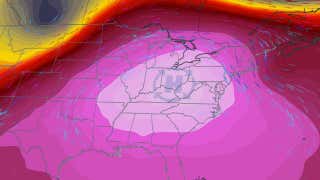
This latest bout of severe weather began in the Plains Monday and Tuesday, where it produced tornadoes, huge hail and high winds from Kansas and Colorado to Minnesota. Now the storm system is spreading east.
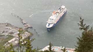
A cruise ship stop in Juneau, Alaska, got a little more exciting than passengers probably expected when the Celebrity Cruises ship “Celebrity Edge” broke from its moorings and started drifting away from the dock. Watch this video to see how a sudden severe storm caused the scary incident.
A tornado hit just northwest of Pikes Peak in Colorado, downing hundreds of trees in the process. The storm also brought rain and hail, while knocking out power to some locations.
Dozens of Girl Scouts got a little more adventure than planned when flash floods left them stranded in cabins at North Park, Pennsylvania. Rescue crews quickly arrived and used ropes to get them to safety.